Habitat Modeling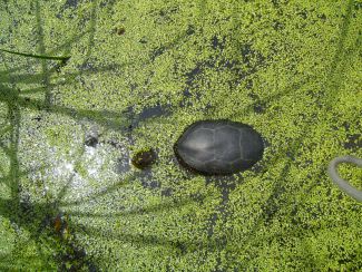
The successful management of species at risk is often built upon knowledge of current remaining habitat. This is challenging when the species is cryptic or difficult to assess in the field, as is true for most reptiles and amphibians. My research uses space-borne satellite imagery to capture regions of interest and identify spatially-explicit areas of remaining suitable habitat across a large scale. The highlights of this research include:
- The use of high spatial resolution satellite imagery which translates into fine detailed maps that can be directly applied to ground level conservation action
- Examination along a seasonal time frame to identify persistent vs ephemeral habitats
- Identification of environmental variables (e.g. vegetation cover, water depth, elevation) that can be used to predict preferred habitat for target species
- Derivation and extraction of these variables from multispectral remotely sensed imagery
 Landscape Connectivity
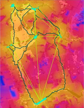
The ability to move across the landscape affects a species ability to find food, mates, suitable nesting sites and to find new habitat when needed. This subsequent focus of my research examines the permeability of different landscapes undergoing increasing levels of human alteration.
Long term population viability is dependent upon the individual’s ability to move across the landscape. Increasing development can place barriers that effectively halt movement and gene flow which will eventually lead to population extinction. Ontario turtles are especially at risk due to high road mortality. My research uses circuit theory (Circuitscape) and random-walk models (Linkage Mapper) to predict movement paths and identify barriers to connectivity. Working with municipal agencies such as the Ministry of Transportation Ontario (MTO) we can identify bottlenecks and hotspots early on so that mitigation measures can be put in place concurrently with schedule road maintenance work.
Predicting Population Persistence
Population viability analysis (PVA) is used in conservation biology as a means to assess the probability of extinction for a given species or population. Ongoing work in this area will use the HexSim model to simulate turtle population dynamics and interactions within the landscape. Continuing development is a major cause of habitat destruction, degradation and fragmentation, therefore PVA models such as HexSim can be used in a relative analysis to compare future outcomes of varying management scenarios.
Object-based image analysis and landcover classification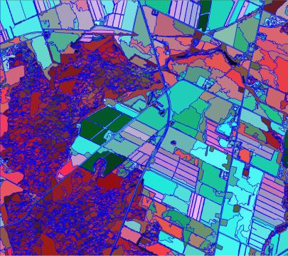
Landcover maps are often used as a pivotal layer in modeling habitat suitability and connectivity. The ability to create landcover maps at a scale suitable to the species or taxonomic group being studied, is critical in achieving accurate results and predictions. My work uses an object-based approach which segments images into meaningful objects for classification in a hierarchical process. Features of interest such as wetlands have been classified up to an 80% accuracy across landscapes of varying disturbance using a combination of spectral, textural and contextual features.
Publications
Mui, A., Caverhill, B., Johnson, B., Fortin, M.J., and He, Y. (2016) Using multiple metrics to estimate seasonal landscape connectivity for Blanding's turtles (Emydoidea blandingii) in a fragmented landscape. Landscape Ecology. Available online. (2015 Impact Factor: 3.657)
Mui, A., Edge, C.B., Paterson, J., Caverhill, B., Johnson, B., Litzgus, J.D., and He, Y. (2016) Nesting sites in agricultural landscapes are may reduce the reproductive success of populations of Blanding's Turtles (Emydoidea blandingii). Canadian Journal of Zoology, 94: 1-7.
Mui, A., He, Y and Weng, Q. (2015) An object-based approach to delineate wetlands across landscapes of varied disturbance with high spatial resolution satellite imagery. ISPRS Journal of Photogrammetry and Remote Sensing, 109: 30-46. (2014 Impact Factor: 3.12)
Murfitt, J., He, Y., Mui, A., Yang, J., and Demille, K. (2015) Ash Decline Assessment in Emerald Ash Borer Infested Natural Forests Using High Spatial Resolution Images. Remote Sensing. 8(3): 256. (2015 Impact Factor: 3.036)
He, Y and Mui, A. (2010) Scaling up Semi-Arid Grassland Biochemical Content from the Leaf to the Canopy Level: Challenges and Opportunities. Sensors, 10: 11072-11087. (2014 Impact Factor: 2.245)
He, Y., Khan, A. and Mui, A . (2010) Integrating Remote Sensing and Wavelet Analysis for Studying Fine-Scaled Spatial Variation among Three Different Ecosystems. Photogrammetric Engineering & Remote Sensing, 78(2): 161-168. (2014 Impact Factor: 1.608)
Research Partners