2023-2029 Quantifying 50 years of abrupt and graduate vegetation changes using multisource remote sensing across complex landscapes
The overall aim of this NSERC DIscovery-funded research is to integrate remote sensing into ecological research for a better understanding of the drivers and mechanisms shaping historical and current changes in vegetative ecosystems and improving conservation efforts. Specifically, we will investigate cumulative and interacting impacts of multiple stressors across vegetative ecosystems and untangle the effects of individual drivers using emerging sources of remote sensing data and cloud-based computing platforms (e.g., Google Earth Engine).
2023-2025 Extreme Hazards Operating Grid Resilience Initiatives
This Hydro One-funded collaborative project aims to provide novel tools that empower Hydro One’s engineers to assess the resilience to extreme weather of Ontario's current and future power grid. My team works closely with Professor Oh-Sung Kwon (https://kwon.civmin.utoronto.ca/)'s team on this project.
2022-2024 Multi-source remote sensing for high-throughput phenotyping of oilseed crops
The objective of this University of Toronto and Zhejiang University joint seed grant-funded project is to develop an intelligent remote sensing monitoring system to map crop attributes at critical growing stages that will enable both bottom-up (growers) and top-down (decision-makers) optimizations of risk migration strategies through multi-source remote sensing, spectral unmixing, and cloud computing.
2022-2024 50 years of spatial-explicit environmental data to examine changes in Northern Canada
The objective of this Data Science Institute-funded program is to build a series of up-to-date, standard, consistent 50-year spatial datasets for northern Canada through integrating Earth observations and climate data. Efforts will be made to incorporate all possible data that would extend the record back to 1970s, supporting more robust statistical analysis. With these datasets, we will address the following research question: To what extent can we gain a more complete understanding of changes that are occurring in northern Canada?
2022-2023 Fine scale land disturbance detection
The purpose of this study is in collaboration with NRCan to develop efficient and accurate automated methods for change detection of fine-scale land disturbances using high-resolution images in the Athabasca oil sand region of Alberta, Canada.
2016-2023 Quantifying vegetation stress from the leaf to landscape scale: integrating lab/field observations, radiative transfer modelling, and UAV hyperspectral imaging system
The objective of this NSERC Discovery-funded program is to further the understanding of why and how vegetation stress induces spectral changes in Canadian grasslands and forests, particularly in response to altering climate conditions and intensified ecological disturbances. Deriving information on the major vegetation disturbance events is a high priority, given the lack of available data, ecosystem susceptibility to impact, and the magnitude of the potential impact downstream.
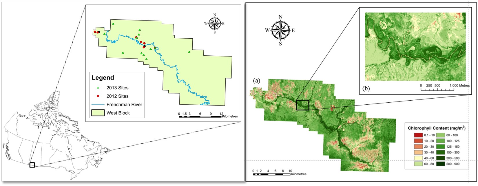
2011-2016 Remote sensing of Canadian grasslands: using vegetation biochemistry to monitor grassland health
NSERC Discovery and Early Career Researcher Supplement funded a project to explore and develop cutting-edge remote sensing methods to estimate spatially-explicit grassland biochemical properties at multiple spatial scales. These methods are essential for further work in carbon sequestration, climate change, ecosystem modelling and grassland ecosystem sustainability.
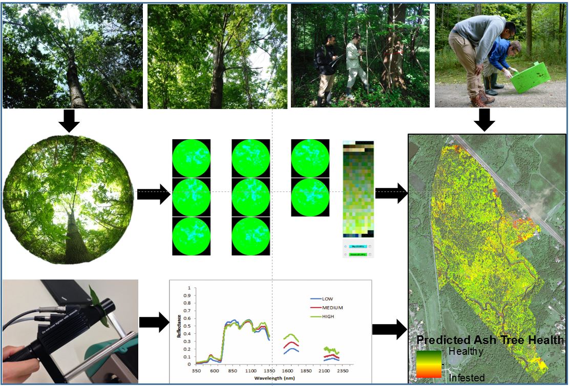
2014-2020 Map trees infested by the emerald ash borer using high spatial resolution remote sensing data
This is a project initially funded by the UTM Office of VP Research in 2013 and then received a 5-year Early Researcher Award from the provincial Ministry of Research and Innovation in 2015 to map EAB infestation in Ontario using field data, satellite images and UAV images. This work collaborates with Credit Valley Conservation and Invasive Species Center.
2011-2015 Remote Sensing and Spatial Ecosystem Modeling (RSSEM) laboratory
Funding from the Canadian Foundation for Innovation and the Ontario Research Fund to establish a laboratory that integrates remote sensing and ecosystem modelling approaches to study the vast Canadian grasslands at multiple levels (species, communities, ecosystem), spatial scales (local to regional), and dimensions (biophysical and biochemical drivers, human causes and climate drives).

2012-2016 Assessing forest biomass as a bioenergy feedstock: the availability and recovery of biomass in uneven-aged forests (This is a collaborative project and PI is Prof. John Caspersen in Forestry at U of Toronto)
The ecoEII funded project is to assess the potential for using forest biomass as feedstock for the production of bioenergy. The project builds upon preliminary work in both of these areas, including remote sensing (LiDAR) of potential biomass availability, as well as biomass harvesting trials designed to assess how much of the biomass can actually be recovered. We will also develop a model (BiOS) that will be made available to companies and agencies as part of FPInterface, a decision support tool for simulating the supply chain of forest operations. The model will help provincial agencies to better allocate wood supply to companies that can best utilize low-quality wood and residues, including harvest blocks that would otherwise be passed over by companies seeking only higher-quality wood.

2011-2013 Using remote sensing to delineate and predict critical wetland habitat and modeling habitat suitability for the Blanding’s turtle (Emydoidea blandingii) in southern Ontario
The aim of this research is to use advanced remote sensing and spatial analysis techniques in conjunction with ecological modeling approaches to identify critical habitat characteristics for the endangered wetland-dependent Blanding’s turtle (Emydoidea blandingii). From this baseline information, further models will be developed through geospatial analysis of species’ movement in order to determine the connectivity of critical wetland and upland habitat leading to the identification of areas in need of protection, restoration or mitigation.
2010-2012 Delineating the endangered vegetative species White Trillium (Trillium grandiflorum) and Wild leek (Allium tricoccum) using remote sensing and GIS technology in Gatineau Park
The NCC funded project to evaluate the utility of multi-date remote sensing data for detection and mapping of endangered wild leek species in Gatineau Park in 2010. NCC funded a second project in 2011 to explore and develop remote sensing methods to map the endangered White Trillium and to improve the accuracy of the Wild leek map from 85% to 90% in Gatineau Park, based on field survey, remote sensing data, and GIS tools.
2010-2012 Object-based grassland biogeochemical modeling
ISTPCanada sub-contract from Prof. Xulin Guo (Geography, U of Saskatchewan) to establish an object-based grassland biogeochemical model and to test the model at different sites in Canadian grasslands.